
- Monday - Friday
- 09:00 - 17:00
- Saturday - Sunday
- Closed
Telephone
01480 539978 or
07973 234099
eVo-air Drones
Drone Operator & Drone Pilot
eVo-air Drone
Aerial Photography
For drone aerial photography and video in Cambridgeshire, Bedfordshire, Essex, Hertfordshire, Northamptonshire, Norfolk, Lincolnshire and Suffolk
eVo-air Drones - your local drone operator covering Bedford, Cambridge, Huntingdon, Oundle, Peterborough, St. Neots and St. Ives - but we'll happily travel wherever you need a professional drone operator you can rely on!
ABOUT ME

Let me help you get a bird's eye view of your construction site, land or property
Drone aerial photographs and drone aerial video are quicker, safer and more efficient than ever before.

Aerial Property Photos
An aerial view of a home for sale shows the whole house and in the context of it's surroundings - crucial for larger homes with large garden or land
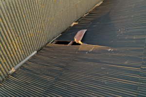
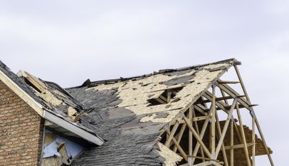
Have You Suffered Storm Damage?
We can organise a drone aerial survey of your storm damage roof or storm damaged building for your insurance company, loss adjuster or simply to help you get quotes for storm damage repairs.
Using the drone aerial photographs can help you get storm damage repairs organised quicker and cheaper - no need for expensive height access equipment, we can usually be with you within 48 hours.
BOOK A DRONE PILOT FOR DRONE AERIAL PHOTOGRAPHY OR DRONE VIDEO
DRONE THERMAL IMAGES
We now have a drone with a specialised thermal camera, which can help identify hot and cold spots on buildings and roofs - identifying poor insulation, water leaks and is also used for search and rescue where we can look for people and animals. We'll add more details soon!
Get a bird's eye view from above with a drone aerial photograph or drone video.
eVo-air Drone Aerial Photography are professional drone operators, CAA authorised and fully insured for drone aerial operations, for drone roof inspections, drone aerial landscapes, drone orthophoto maps and 3D models, for drone pictures of building sites, tall buildings and much more.
Hiring a drone operator and getting drone pictures will be quicker, safer and easier than getting height equipment or manned aircraft.
Ask us for a quote - prices start from just £90 + VAT
Looking for a Freelance Drone Operator?
Drone Aerial Photography
Land & Construction Sites
Drone aerial photographs and drone video help buyers, planners and architects get the full picture of the area. And time-lapse aerial maps can show the progress of projects...

Drone Mapping, Orthophoto images, photogrammetry and 3D models and mapping
By stitching together multiple images, we can build a comprehensive drone aerial map of the land, complete with accurate measuring tools.

FOLLOW ME
Search for @evoairdrones
Latest YouTube Videos
DRONE AERIAL PHOTOGRAPHY


Drone aerial photography across Cambridgeshire
Drone aerial photography and drone aerial video services across East Anglia for a wide variety of applications, specialising in aerial property surveys and drone roof inspections, particularly suitable for residential and commercial property estate agents and surveyors.
Call for a chat about how we can give you a fresh perspective with a bird's eye view from above!
What is a UAS Operator?
There are so many terms used, the latest official definition now to be adopted by the Civil Aviation Authority is Unmanned Aircraft System Operator, "Unmanned Aircraft" refers to any aircraft operating or designed to operate autonomously or to be piloted remotely without a pilot on board.
I'd certainly need a radical diet to get on board even the largest of my drones!.


eVo-air Drone Aerial Photography holds the necessary CAA Permission to undertake commercial drone operations as a UAS Operator, previously known as PfCO, now renamed Operational Authorisation from 2021 and offers drone aerial photography and drone aerial video throughout East Anglia and the Midlands, including Bedfordshire, Cambridgeshire, Essex, Hertfordshire, Northamptonshire, Norfolk and Suffolk - and anywhere else you want us!
Telephone 07973 234099
Copyright © All Rights Reserved